I picked them up around 9:15 and we were getting on the on-ramp to I80 when we hit standstill traffic. It was like a parking lot. The highways were also experiencing serious overflow because of the BART shutdown so we settled in for a long drive up to and across the Bay Bridge into SF. This allowed us time to talk for a bit since we may or may not see each other again because they may be off to Kentucky before I get back from camp. It was a slow grueling haul and what should have only taken thirty minutes tripled. I finally dropped them off near their workplaces by 11:00AM and I was finally ready to head out. I went right back across the Bay Bridge but going east was no problem, though I80 west was still backed up for miles and miles.
At this point I had two routes which I could have taken. The first was all major interstate highways and would have had me on the I80 east out of the Bay Area, through Sacramento, into Nevada where I would have headed north on U.S. Route 95 through Nevada and into Idaho, where it would meet up with I84 in Boise, which then proceeds north west into the northeastern corner Oregon, where I would have exited in the city of La Grande and Cove is 15 miles west of La Grande. I84 then heads due west to Portland and the Oregon coast but I won't have to travel that yet. However the other route I ended up taking consisted of a few major interstates but it was mostly state highways that weaved north through Northern California and into the south central part of Oregon and more state highways until I would meet up with I84 a few miles south of La Grande. I opted for the second route because the highways were mostly rural two lane roads that had little traffic and because I would see parts of California and Oregon that I would probably never again have the chance to see. I am glad I did because I saw so much and drove through through very diverse landscapes, it was absolutely awesome. So lets start at the beginning as I left SF.
I headed out the I80 east until I reached the I505 just south of Vallejo, CA which sort of marks the northeastern edge of what is considered the Bay Area. As I climbed over the ridges that surround the Bay Area and made my north on the I505, in order to avoid having to drive though Sacramento, the landscape began to change. The hills littered with houses gave way to pastures and fields. I drove through rolling hills of green fertile farmland. After maybe an hour or so on the I505 I met up with the I5 which would be my main road into the heart of Northern California and I was on that highway for a few hours as I slowly approached the southern end of the Cascade Mountain range. I made a quick pit stop after getting onto the I5 just south Arbuckle, CA. I purchased a Mountain Dew and was back on the road again. As I cruised down the I5 the landscape changed from farmland to rolling hills of brown as far as my eyes could see.

The rolling hills of brown and yellow

If
you click on the picture it should enlarge and you can see the Jesus
bumper stickers, it nice to see truckers are still religious

My view as I traveled down the I5 towards Redding where the Cascades begin/end depending on your point of view

Another view down the I5 corridor traveling north through the center of Northern California

Rolling hills with clusters of trees scattered around
After
driving almost 130 miles along the I5 my route diverged from the major
interstates and it was all US Routes and state highways to my stop for
the night. Once I hit Redding,
which is in the center of Norther California and about 150 miles or
less from the border of Oregon, I took CA299 east which would take me
northwest towards Nevada and the south central section of Oregon. Once I
started driving down CA299 the terrain began to change dramatically.
The rolling hills gave way to more rugged terrain and the flowing fields
turned into forests. The Cascades loomed in the distance with the
prominent Mount Shasta in clear view. Because Mount Shasta is just of
14,000 feet high and is not surrounded by any other large mountain peaks
I was able to see for awhile I drew closer to my exit for CA299. Once I
started heading east Shasta was in my rear-view along with the rest of
the Cascades as CA299 skirts the eastern edge of Shasta National
Forest. The terrain continued to become more diverse as I slowly
climbed in elevation and made my way through gorges and up and over
small mile high mountains. I stayed on CA299 for another 150 miles
passing through some of the more remote areas of Northern California. I
drove through two very large National Parks with few other travelers in
either direction and I had some amazing views. I stopped every once in
a while to get pictures because it was so amazing. After nearly two
and a half hours on CA299 I reached the town of Alturas and my next juncture with US Route 395 which would take me north into Oregon.

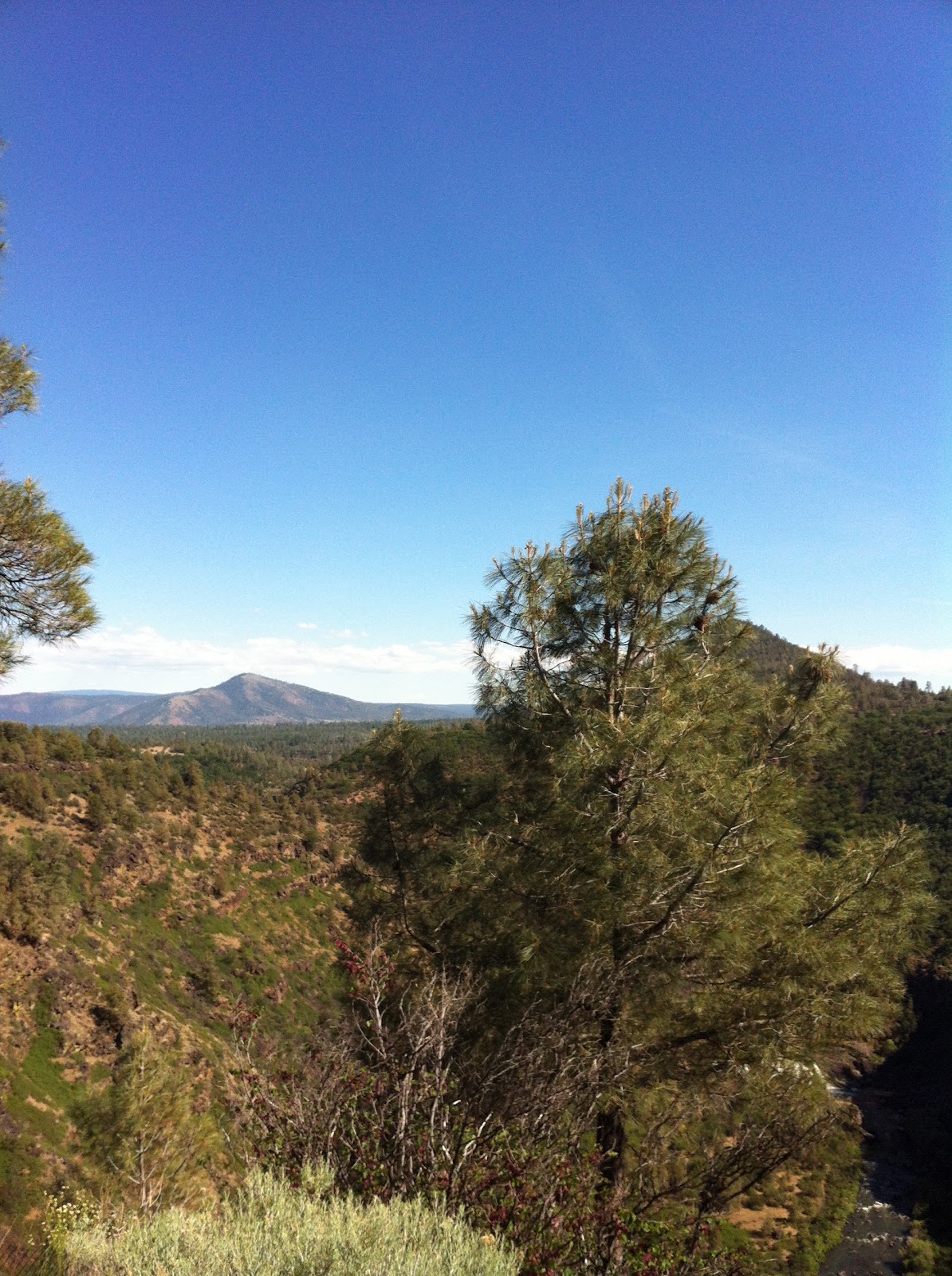
On the two lane CA299 there were amazing views of rolling foothills

Mountains off in the distance

More mountains off in the distance

A river cutting through the foothills near the tiny town of McArthur, CA

Just another picture of the amazing views
Yet another view

Another
view as I left the foothills in Norther California and approached the
elevated plateau and high desert of the south central section of Oregon
As I turned north onto US Route 395 I was not far form my stop in Lakeview,
Oregon with only about 50 miles to go for the day. As I left the
mountainous region of northern California, I was beginning to near what
is know as the Oregon Outback. It is called this because if its
elevated, wide open land and sparse population. For most of my ride on
the 395 towards the border there was no one else traveling on the road,
with the exception of a few trucks. I was about 20 miles south of Lakeview when I came upon a gigantic glacial lake called Goose Lake. It straddles the border of California and Oregon and Lakeview,
as you can imagine by its name is on the northern end of the lake. As I
approached the lake I was beginning to see why this was called the
outback but not yet convinced it was high desert. Then as I approached
the lake a ridge rose up on my right as I hugged it while driving along
the eastern shore. I rode along the shore for what felt like forever
and then about halfway up the lake I entered Oregon. Finally made it to
a new state and another one to mark off my list of places I have been.
I continued to follow the eastern shore, stopping to get some pictures,
and then finally left the lake behind as I pulled into the tiny hamlet
of Lakeview
at an elevation of over a mile high. I found my hotel, walked to the
local "drive-in" called the Burger Queen, sampled one of their fine
burgers and a side of onion rings and settled into my room for a well
deserved rest. I touched base with my family by texting
my brother to let my mom know that I made it safely and I also had a
chance to talk with Lauren before calling it a night. I was excited for
the second leg because I had no idea what was waiting for me as my
route was going to take me through some of the most remote parts of
Oregon and up to the northeastern corner of the state.

The
beginnings of the Oregon Outback as the mountainous Northern California
gave way to the vast expanse of nothingness ahead of me, yet it was
amazingly beautiful...as you can see not another soul on the road, it
was amazing to feel that isolation in God's creation

The absence of trees gave me the hint that I was either at a high elevation or truly heading into the outback or both

All by myself in the middle of nowhere

The lake began to appear in the distance

A look out at some trees that lined the area around the lake

The south eastern shore of Goose Lake

Again, no one else on the road with the ridge surrounding the lake rising up in front of me and to my right

A more elevated view of the lake

Another view of the lake

A sign just off the road that shows the many rivers/creeks that flow in and out of Goose Lake

The Safeway in Lakview, I liked the cowboy

Another restaurant popular with the locals but I decided not go there and it was in the parking lot of the Safeway

The little white building is Lakeview City Hall

A closer look at City Hall

The
Burger Queen "drive-in"...I put drive-in in quotation marks because to
me a drive-in is a place where one would drive their car in to a large
lot and watch a
movie, but apparently in Oregon a drive-in is another name for a
drive-through that sells grill food and ice cream shakes/cones...I was
fooled again when I finally got to Cove to find out the "drive-in" that I
was told about was not really a drive-in but a drive-through...wuh wuh

The Burger Queen...it did have good burgers

No comments:
Post a Comment